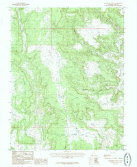
1985 Map of Bradford Canyon
USGS Topo · Published 1985About this map
Alkali Point dominates the central landscape of this San Juan County quadrangle, forming a high, dissected plateau that separates numerous drainage systems. To the west, the broad expanse of Mustang Mesa provides a stark contrast to the intricate network of canyons that carve through the sedimentary layers. This 1985 provisional survey captures a wilderness landscape defined by water and wind, where Alkali Canyon and Bradford Canyon converge amidst a labyrinth of sandstone features. On the eastern edge, Montezuma Creek flows through a deep corridor, joined by tributaries such as Horse Canyon and Deadman Canyon. The map reveals a high-desert environment with localized features like Bullpen Swale and Cave Canyon, illustrating the complex topography of southeastern Utah before significant modern development altered these traditional grazing and resource areas.
Find a feature on this map
10 named features on this map. Tap any name to fly to it.
Don’t see what you’re looking for? This feature index may not catch every label — zoom into the map to look around manually.
Map Details
Editions of this 1985 Bradford Canyon Map
This is the sole edition of this map. No revisions or reprints were ever made.
Other maps of this area

1886 · Abajo
USGS Topo · 1:250,000

1892 · Abajo
USGS Topo · 1:250,000

1893 · Abajo
USGS Topo · 1:250,000

1955 · Verdure 4 NW
USGS Topo · 1:24,000

1955 · Verdure 3 SE
USGS Topo · 1:24,000

1955 · Verdure 4 SW
USGS Topo · 1:24,000

1955 · Verdure 3 NE
USGS Topo · 1:24,000

1956 · Cortez
USGS Topo · 1:250,000

1957 · Aneth 1 NW
USGS Topo · 1:24,000

1957 · Monument Canyon
USGS Topo · 1:62,500