
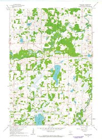
1961 Map of Bradford
USGS Topo · Published 1963About this map
The Rum River meanders through Isanti County, defining the rural character of this landscape in the early 1960s. The settlement of Bradford and the crossroads of Walbo anchor a region shaped by glacial lakes and fertile bottomlands. Residential development is visible along the margins of Lake Francis, specifically at West Lake Francis Shores and East Lake Francis Shores, signaling the post-war growth of recreational and seasonal housing in Minnesota's lake country.
Find a feature on this map
22 named features on this map. Tap any name to fly to it.
Don’t see what you’re looking for? This feature index may not catch every label — zoom into the map to look around manually.
Map Details
Editions of this 1961 Bradford Map
2 editions found
Other maps of this area

1916 · St. Francis
USGS Topo · 1:62,500

1919 · St. Francis
USGS Topo · 1:62,500

1953 · Stillwater
USGS Topo · 1:250,000

1955 · Isanti
USGS Topo · 1:62,500

1955 · Stillwater
USGS Topo · 1:250,000

1958 · Stillwater
USGS Topo · 1:250,000

1961 · Cambridge
USGS Topo · 1:62,500

1961 · Springvale
USGS Topo · 1:24,000

1961 · Dalbo
USGS Topo · 1:24,000

1961 · Wyanett
USGS Topo · 1:24,000