
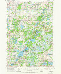
1955 Map of Isanti
USGS Topo · Published 1957About this map
Glacial lake basins and marshlands dominate this mid-century landscape where the Sunrise River North Branch and West Branch drain toward the St. Croix valley. The topography is defined by dozens of water bodies, from the large Coon Lake Beach complex to smaller basins like Fish Lake and Typo Lake. The rural character of the era is evident in the dense network of small schoolhouses and country cemeteries, several of which were already marked as historical remnants, such as the School No 37 and Lone Elm Sch. In the eastern section, the Carlos Avery State Game Refuge and Public Hunting Grounds preserves a significant portion of the wetland environment. Small settlements like Isanti, Linwood, and Soderville serve as anchor points for a community still heavily tied to the local land and its numerous lakes.
Find a feature on this map
76 named features on this map. Tap any name to fly to it.
Don’t see what you’re looking for? This feature index may not catch every label — zoom into the map to look around manually.
Map Details
Editions of this 1955 Isanti Map
2 editions found
Other maps of this area

1902 · White Bear
USGS Topo · 1:62,500

1902 · Anoka
USGS Topo · 1:62,500

1916 · St. Francis
USGS Topo · 1:62,500

1919 · St. Francis
USGS Topo · 1:62,500

1948 · Stillwater
USGS Topo · 1:62,500

1949 · Stillwater
USGS Topo · 1:62,500

1950 · Rush City
USGS Topo · 1:48,000

1952 · Centerville
USGS Topo · 1:24,000

1953 · Stillwater
USGS Topo · 1:250,000

1954 · Hugo
USGS Topo · 1:24,000