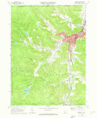
1969 Map of Bradford
USGS Topo · Published 1973About this map
Bradford serves as the industrial and cultural anchor for McKean County, where the convergence of the Erie Lackawanna, Baltimore and Ohio, and Penn Central railroads illustrates a legacy of mid-century transport and commerce. The city's growth is marked by institutions such as the University of Pittsburgh at Bradford and a prominent Hospital. Southward along the East Branch and West Branch of Tuna Creek, the landscape transitions into the wooded expanse of the Allegheny National Forest. Scattered settlements like Degolia, Custer City, and Lewis Run follow the valley floor, interspersed with dozens of oil wells that highlight the region's enduring extractive history. To the west, the topography rises sharply toward Hedgehog Hollow and Brown Valley, where a series of municipal water sources including Reservoir No 1 and Reservoir No 5 are tucked away in the drainages.
Find a feature on this map
67 named features on this map. Tap any name to fly to it.
Don’t see what you’re looking for? This feature index may not catch every label — zoom into the map to look around manually.
Map Details
Editions of this 1969 Bradford Map
3 editions found
Other maps of this area

1900 · Salamanca
USGS Topo · 1:62,500

1922 · Randolph
USGS Topo · 1:62,500

1923 · Randolph
USGS Topo · 1:62,500

1924 · Bradford
USGS Topo · 1:62,500

1926 · Bradford
USGS Topo · 1:62,500

1936 · Kinzua
USGS Topo · 1:48,000

1938 · Salamanca
USGS Topo · 1:62,500

1941 · Kinzua
USGS Topo · 1:62,500

1941 · Bradford
USGS Topo · 1:62,500

1943 · Randolph
USGS Topo · 1:62,500