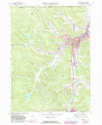
1969 Map of Bradford
USGS Topo · Published 1991About this map
The valley of Tunungwant Creek serves as the industrial and civic spine for Bradford and its southern satellite communities. This McKean County landscape is defined by the intersection of heavy rail and steep Pennsylvania terrain, with the Baltimore and Ohio and Conrail lines following the narrow corridor through Degolia and Custer City. The town’s social fabric is visible in its numerous educational and religious sites, including the University of Pittsburgh at Bradford, St Bernards Cem, and Willow Dale Cem. The northern reach of the Allegheny National Forest borders the western hills, where a network of reservoirs and brooks like Marilla Brook and Reservoir No 5 supplied the region's growing population. Numerous oil wells dot the hollows, reflecting the enduring legacy of the local petroleum industry that shaped these hills and communities like Hazelton Mills and Lewis Run.
Find a feature on this map
71 named features on this map. Tap any name to fly to it.
Don’t see what you’re looking for? This feature index may not catch every label — zoom into the map to look around manually.
Map Details
Editions of this 1969 Bradford Map
3 editions found
Other maps of this area

1900 · Salamanca
USGS Topo · 1:62,500

1922 · Randolph
USGS Topo · 1:62,500

1923 · Randolph
USGS Topo · 1:62,500

1924 · Bradford
USGS Topo · 1:62,500

1926 · Bradford
USGS Topo · 1:62,500

1936 · Kinzua
USGS Topo · 1:48,000

1938 · Salamanca
USGS Topo · 1:62,500

1941 · Kinzua
USGS Topo · 1:62,500

1941 · Bradford
USGS Topo · 1:62,500

1943 · Randolph
USGS Topo · 1:62,500