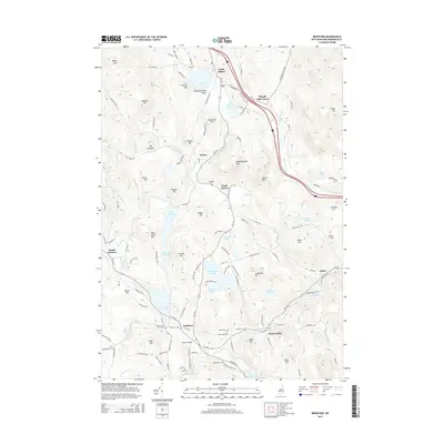
2015 Map of Bradford
USGS Topo · Published 2015About this map
Kezar Lake and the various villages of the Lane River valley define this portion of Merrimack County. The landscape is a network of small settlements like North Sutton, Sutton, and South Sutton, connected by winding roads that skirt the numerous glacial lakes and hills. In the southern reach, the Warner River flows through Bradford, passing landmarks such as Bemet Bridge and the Warner River Reservoir. Local history is deeply etched into the terrain through family-named features like Porter Hill, Fellows Hill, and Gage Hill, alongside historic burial grounds including Millwoods Cem and Union Cem. The presence of Wadleigh State Beach and the extensive shoreline of Lake Massasecum illustrates the area's transition into a destination for water-based recreation. Higher elevations such as Kings Hill and The Pinnacle provide significant relief against the densely clustered brooks and ponds that feed the local watershed.
Find a feature on this map
131 named features on this map. Tap any name to fly to it.
Don’t see what you’re looking for? This feature index may not catch every label — zoom into the map to look around manually.
Map Details
Editions of this 2015 Bradford Map
This is the sole edition of this map. No revisions or reprints were ever made.
Other maps of this area

1902 · Sunapee
USGS Topo · 1:62,500

1905 · Sunapee
USGS Topo · 1:62,500

1907 · Sunapee
USGS Topo · 1:62,500

1926 · Hillsboro
USGS Topo · 1:62,500

1928 · Mount Kearsarge
USGS Topo · 1:62,500

1929 · Hillsboro
USGS Topo · 1:62,500

1930 · Lovewell Mountain
USGS Topo · 1:62,500

1931 · Mount Kearsarge
USGS Topo · 1:62,500

1942 · Lovewell Mountain
USGS Topo · 1:62,500

1949 · Portland
USGS Topo · 1:250,000