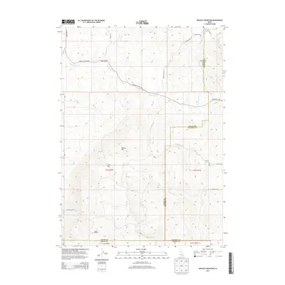
2013 Map of Bradley Mountain
USGS Topo · Published 2013About this map
Bradley Mountain dominates this high-country landscape at the junction of Bannock, Power, and Oneida counties. The map traces a complex network of seasonal water sources and drainages, including Hawkins Spring, Bull Spring, and Rock Spring, which likely served as vital landmarks for early ranching and travel through this segment of southeastern Idaho. Transportation follows the natural contours of the terrain, defined by routes such as Upper Rattlesnake Rd and Knox Canyon Rd E. Evidence of the area's resource-based history appears in names like Mine Canyon and Dairy Creek, while the presence of Eagle Pass indicates a primary corridor through the mountainous topography. Several creeks, including Rattlesnake Creek and Deadwood Creek, carve through the various townships, providing a clear picture of the local watershed before it exits the quadrangle.
Find a feature on this map
31 named features on this map. Tap any name to fly to it.
Don’t see what you’re looking for? This feature index may not catch every label — zoom into the map to look around manually.
Map Details
Editions of this 2013 Bradley Mountain Map
This is the sole edition of this map. No revisions or reprints were ever made.
Other maps of this area

1938 · Pauline
USGS Topo · 1:48,000

1944 · Arbon
USGS Topo · 1:62,500

1954 · Pocatello
USGS Topo · 1:250,000

1958 · Pocatello
USGS Topo · 1:250,000

1968 · Dairy Creek
USGS Topo · 1:24,000

1968 · Wakley Peak
USGS Topo · 1:24,000

1968 · Hawkins
USGS Topo · 1:24,000

1968 · Clifton Creek
USGS Topo · 1:24,000

1968 · Bradley Mtn
USGS Topo · 1:24,000
1968 · Scout Mtn
USGS Topo · 1:24,000