
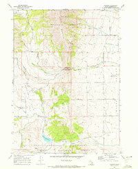
1968 Map of Hawkins
USGS Topo · Published 1972About this map
Old Tom Mountain and Cedar Mountain dominate this section of the Caribou National Forest in southeastern Idaho, where high-elevation ridges overlook the distinctive Hawkins Basin. The small settlement of Hawkins sits at the nexus of several local routes, including Vandyke Road and Quigley Road, serving as a central point for the surrounding ranching and agricultural landscape. A notable historical feature is the Emigrant Trail, which winds through the center of the quadrangle, following the natural passage through the mountains toward the Marsh Valley. To the south, the Hawkins Reservoir manages the flow of Hawkins Creek and its tributaries, such as Yellow Dog Creek and South Fork Hawkins Creek. This 1960s-era topography reveals a network of family-named roads, like Thacker Road and Armstrong Road, that connect the valley floors to the more isolated mountain gaps.
Find a feature on this map
43 named features on this map. Tap any name to fly to it.
Don’t see what you’re looking for? This feature index may not catch every label — zoom into the map to look around manually.
Map Details
Editions of this 1968 Hawkins Map
2 editions found
Other maps of this area

1954 · Pocatello
USGS Topo · 1:250,000

1958 · Pocatello
USGS Topo · 1:250,000

1968 · Dairy Creek
USGS Topo · 1:24,000

1968 · Downey West
USGS Topo · 1:24,000

1968 · Wakley Peak
USGS Topo · 1:24,000

1968 · Clifton Creek
USGS Topo · 1:24,000
1968 · Arimo
USGS Topo · 1:24,000

1968 · Bradley Mtn
USGS Topo · 1:24,000

1968 · Mc Cammon
USGS Topo · 1:24,000
1968 · Scout Mtn
USGS Topo · 1:24,000