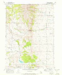
1968 Map of Hawkins
USGS Topo · Published 1972About this map
Old Tom Mountain and the high ridges of the Caribou National Forest dominate this late 1960s survey of southeastern Idaho. The landscape is defined by the steep transition from the timbered heights of Cedar Mountain down to the agricultural expanses of Marsh Valley. Of significant historical interest is the Old Emigrant Trail, which winds through the center of the map, marking the path of 19th-century westward migration across this high desert terrain.
Find a feature on this map
44 named features on this map. Tap any name to fly to it.
Don’t see what you’re looking for? This feature index may not catch every label — zoom into the map to look around manually.
Map Details
Editions of this 1968 Hawkins Map
2 editions found
Other maps of this area

1954 · Pocatello
USGS Topo · 1:250,000

1958 · Pocatello
USGS Topo · 1:250,000

1968 · Dairy Creek
USGS Topo · 1:24,000

1968 · Downey West
USGS Topo · 1:24,000

1968 · Wakley Peak
USGS Topo · 1:24,000

1968 · Hawkins
USGS Topo · 1:24,000

1968 · Clifton Creek
USGS Topo · 1:24,000
1968 · Arimo
USGS Topo · 1:24,000

1968 · Bradley Mtn
USGS Topo · 1:24,000

1968 · Mc Cammon
USGS Topo · 1:24,000