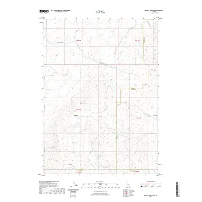
2020 Map of Bradley Mountain
USGS Topo · Published 2020About this map
Bradley Mtn and Eagle Pass dominate this high-elevation corner of Idaho where the boundaries of Bannock, Power, and Oneida counties meet. The landscape is defined by its complex drainage network, where seasonal and perennial flows like Rattlesnake Cr and Yellow Dog Cr carve through the high country. Resource extraction history is signaled by the presence of Mine Canyon in the southern portion of the quadrangle, while several vital water sources including Hawkins Spring and Bull Spring suggest the importance of water management in this arid environment. The road network is primarily composed of light-duty and unimproved routes such as Upper Rattlesnake Rd and Knox Canyon Rd, reflecting the remote and undeveloped character of the terrain during this early 21st-century survey.
Find a feature on this map
32 named features on this map. Tap any name to fly to it.
Don’t see what you’re looking for? This feature index may not catch every label — zoom into the map to look around manually.
Map Details
Editions of this 2020 Bradley Mountain Map
This is the sole edition of this map. No revisions or reprints were ever made.
Other maps of this area

1938 · Pauline
USGS Topo · 1:48,000

1944 · Arbon
USGS Topo · 1:62,500

1954 · Pocatello
USGS Topo · 1:250,000

1958 · Pocatello
USGS Topo · 1:250,000

1968 · Dairy Creek
USGS Topo · 1:24,000

1968 · Wakley Peak
USGS Topo · 1:24,000

1968 · Hawkins
USGS Topo · 1:24,000

1968 · Clifton Creek
USGS Topo · 1:24,000

1968 · Bradley Mtn
USGS Topo · 1:24,000
1968 · Scout Mtn
USGS Topo · 1:24,000