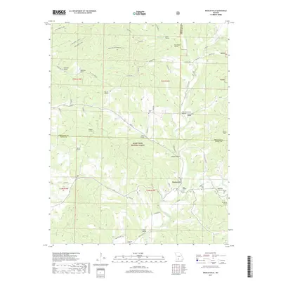
2017 Map of Bradleyville
USGS Topo · Published 2017About this map
Bradleyville sits at the intersection of State Highway 76 and 125, serving as a focal point for this section of Taney and Christian counties. Much of the landscape is dominated by the Mark Twain National Forest, where steep drainages and hollows like Warren Hollow and Clayton Hollow dictate the local road network. The map reveals a deeply rooted rural community, marked by family-named landmarks and cemeteries such as Mills Cem and Martin Cem found near the ridge tops and valley floors. Notable watercourses including Beaver Creek and its many tributaries, like Dick Br and Little Beaver Cr, carve through the terrain. Evidence of local industry and legacy infrastructure appears in labels like Old Cheese Plant Rd, hinting at the agricultural history of the region. The map captures a point in time where traditional names like Kentucky Hollow persist alongside contemporary forest management boundaries.
Find a feature on this map
68 named features on this map. Tap any name to fly to it.
Don’t see what you’re looking for? This feature index may not catch every label — zoom into the map to look around manually.
Map Details
Editions of this 2017 Bradleyville Map
This is the sole edition of this map. No revisions or reprints were ever made.
Other maps of this area

1907 · Forsyth
USGS Topo · 1:125,000

1937 · Bradleyville
USGS Topo · 1:48,000

1943 · Protem
USGS Topo · 1:62,500

1943 · Bradleyville
USGS Topo · 1:62,500

1945 · Harrison
USGS Topo · 1:250,000

1945 · Bradleyville
USGS Topo · 1:62,500

1949 · Harrison
USGS Topo · 1:250,000

1954 · Harrison
USGS Topo · 1:250,000

1955 · Garrison
USGS Topo · 1:24,000
1955 · Chadwick
USGS Topo · 1:24,000