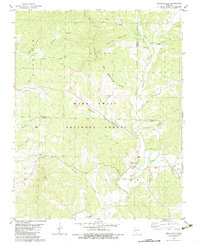
1982 Map of Bradleyville
USGS Topo · Published 1983About this map
Bradleyville sits at the junction of several key waterways in the southern Missouri Ozarks during the late 1970s and early 1980s. The landscape is defined by the winding course of Beaver Creek and its many tributaries, such as Little Beaver Creek and Roller Creek. This survey captures a region deeply connected to its rural roots and physical geography, evidenced by the numerous family-named landmarks and hollows that dominate the terrain. A notable cultural feature is the presence of Charcoal Ovens near Poague Hollow, hinting at local timber processing or historical industry within the Mark Twain National Forest.
Find a feature on this map
40 named features on this map. Tap any name to fly to it.
Don’t see what you’re looking for? This feature index may not catch every label — zoom into the map to look around manually.
Map Details
Editions of this 1982 Bradleyville Map
This is the sole edition of this map. No revisions or reprints were ever made.
Other maps of this area

1907 · Forsyth
USGS Topo · 1:125,000

1937 · Bradleyville
USGS Topo · 1:48,000

1943 · Protem
USGS Topo · 1:62,500

1943 · Bradleyville
USGS Topo · 1:62,500

1945 · Harrison
USGS Topo · 1:250,000

1945 · Bradleyville
USGS Topo · 1:62,500

1949 · Harrison
USGS Topo · 1:250,000

1954 · Harrison
USGS Topo · 1:250,000

1955 · Garrison
USGS Topo · 1:24,000
1955 · Chadwick
USGS Topo · 1:24,000