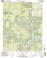
2004 Map of Bradleyville
USGS Topo · Published 2006About this map
Bradleyville sits at the intersection of a complex network of Ozark waterways and hollows, where Beaver Creek and Little Beaver Creek meet. This 2004 revision of earlier surveys shows a landscape deeply defined by the Mark Twain National Forest, including a designated Non-Motorized Area in the northern reach. The map is a valuable resource for family historians, documenting several rural burying grounds such as Blair Cem, Whitaker Cem, and Patterson Cem located near the southern border.
Find a feature on this map
49 named features on this map. Tap any name to fly to it.
Don’t see what you’re looking for? This feature index may not catch every label — zoom into the map to look around manually.
Map Details
Editions of this 2004 Bradleyville Map
This is the sole edition of this map. No revisions or reprints were ever made.
Other maps of this area

1907 · Forsyth
USGS Topo · 1:125,000

1937 · Bradleyville
USGS Topo · 1:48,000

1943 · Protem
USGS Topo · 1:62,500

1943 · Bradleyville
USGS Topo · 1:62,500

1945 · Harrison
USGS Topo · 1:250,000

1945 · Bradleyville
USGS Topo · 1:62,500

1949 · Harrison
USGS Topo · 1:250,000

1954 · Harrison
USGS Topo · 1:250,000

1955 · Garrison
USGS Topo · 1:24,000
1955 · Chadwick
USGS Topo · 1:24,000