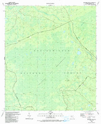
1990 Map of Bradwell Bay
USGS Topo · Published 1990About this map
Apalachicola National Forest dominates this landscape, defined by the intricate hydrology of the Florida panhandle's swamp and pine woods. The Bradwell Bay Wilderness occupies the central portion of the sheet, where the land transitions into a dense titi swamp and pine flatwood environment. This protected interior is navigated by the Florida National Scenic Trail, which winds through the southern and eastern sectors, providing a rare traversable path through the saturated terrain. Along the northern and eastern reaches, the Sopchoppy River and Monkey Creek drain the boggy expanse of Bradwell Bay and Mosquito Bay. Evidence of localized industry appears in the form of several Sandpits near the river, contrasting with the strictly managed wilderness areas marked by the Wilderness Boundary.
Find a feature on this map
11 named features on this map. Tap any name to fly to it.
Don’t see what you’re looking for? This feature index may not catch every label — zoom into the map to look around manually.
Map Details
Editions of this 1990 Bradwell Bay Map
This is the sole edition of this map. No revisions or reprints were ever made.
Other maps of this area

1940 · Tallahassee
USGS Topo · 1:62,500

1940 · Arran
USGS Topo · 1:62,500

1942 · Tallahassee
USGS Topo · 1:62,500

1943 · Arran
USGS Topo · 1:62,500

1943 · Tallahassee
USGS Topo · 1:62,500

1943 · Lake Talquin
USGS Topo · 1:62,500

1945 · Thousand Yard Bay
USGS Topo · 1:31,680

1945 · Smith Creek
USGS Topo · 1:31,680

1945 · Bradwell Bay
USGS Topo · 1:31,680

1945 · Sanborn
USGS Topo · 1:31,680