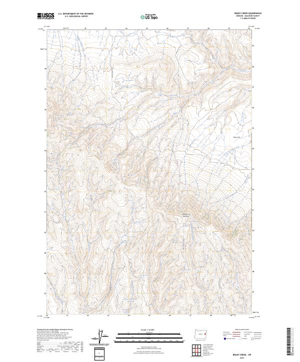
2023 Map of Brady Creek
USGS Topo · Published 2023About this map
Cottonwood Mountain stands as the central topographic focal point of this Malheur County landscape, where a sophisticated network of ephemeral water sources and springs sustained high-desert activity. The map reveals a reliance on vital water points such as Chokecherry Spring, Grey Horse Spring, and Antelope Spring, which are scattered throughout the drainages. Man-made interventions in the hydrology are evident at the Upper Buckbrush Reservoir and the primary Buckbrush Reservoir, indicating managed water resources for livestock or land use in an otherwise arid environment. Navigation across this terrain is defined by a handful of established tracks, including Juniper Mtn Rd and Dry Creek Loop Rd. The area is further characterized by distinct flats and gulches, such as Thorn Flat, that break the elevation patterns of the surrounding ridges and creeks like Brady Creek and Brian Creek.
Find a feature on this map
36 named features on this map. Tap any name to fly to it.
Don’t see what you’re looking for? This feature index may not catch every label — zoom into the map to look around manually.
Map Details
Editions of this 2023 Brady Creek Map
This is the sole edition of this map. No revisions or reprints were ever made.
Other maps of this area

1955 · Baker
USGS Topo · 1:250,000

1959 · Baker
USGS Topo · 1:250,000

1964 · Bridgeport
USGS Topo · 1:62,500

1964 · Brogan
USGS Topo · 1:62,500

1964 · Ironside
USGS Topo · 1:62,500

1966 · Clover Creek Ranch
USGS Topo · 1:62,500

1980 · Brogan
USGS Topo · 1:100,000
1990 · Brady Creek
USGS Topo · 1:24,000
1990 · Scratch Post Butte
USGS Topo · 1:24,000
1990 · Cow Valley West
USGS Topo · 1:24,000