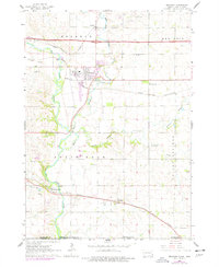
1962 Map of Brandon
USGS Topo · Published 1977About this map
Split Rock Creek and the Big Sioux River converge south of Brandon, forming a landscape defined by water and heavy industry during the mid-20th century. The area is a hub of transportation and resource extraction, with the Great Northern, Illinois Central, and Chicago and North Western railroads all crossing the territory to serve regional commerce. Numerous quarries and gravel pits are scattered near East Sioux Falls and Rowena, indicating the importance of the local stone and aggregate industry.
Find a feature on this map
26 named features on this map. Tap any name to fly to it.
Don’t see what you’re looking for? This feature index may not catch every label — zoom into the map to look around manually.
Map Details
Editions of this 1962 Brandon Map
2 editions found
Other maps of this area

1897 · Canton
USGS Topo · 1:125,000

1900 · Canton
USGS Topo · 1:125,000

1955 · Sioux Falls
USGS Topo · 1:250,000

1958 · Sioux Falls
USGS Topo · 1:250,000

1962 · Renner
USGS Topo · 1:24,000

1962 · Klondike
USGS Topo · 1:24,000

1962 · Harrisburg
USGS Topo · 1:24,000

1962 · Brandon
USGS Topo · 1:24,000

1962 · Sioux Falls East
USGS Topo · 1:24,000

1962 · Garretson West
USGS Topo · 1:24,000