
1962 Map of Garretson West
USGS Topo · Published 1964About this map
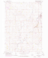
Split Rock Creek carves a significant course through this portion of Minnehaha County, following a winding path that anchors the local geography. The town of Garretson sits at the northeastern edge of the survey, where the Great Northern railroad lines converge and head south toward the Palisades Recreational Area. This landscape is defined by its rural civic structure, evidenced by the regular spacing of one-room schoolhouses such as White Willow Sch, Fairview Sch, and Pleasant View Sch. The presence of Norway Ch and Split Rock Ch with its adjacent Split Rock Ch Cem highlights the importance of traditional community centers. The confluence of West Pipestone Creek and Split Rock Creek creates a complex drainage pattern that influenced the original layout of the townships of Edison, Palisade, Brandon, and Red Rock.
Find a feature on this map
20 named features on this map. Tap any name to fly to it.
Don’t see what you’re looking for? This feature index may not catch every label — zoom into the map to look around manually.
Map Details
Editions of this 1962 Garretson West Map
2 editions found
Other maps of this area

1955 · Sioux Falls
USGS Topo · 1:250,000

1958 · Sioux Falls
USGS Topo · 1:250,000

1962 · Dell Rapids
USGS Topo · 1:24,000

1962 · Renner
USGS Topo · 1:24,000

1962 · Brandon
USGS Topo · 1:24,000

1962 · Sioux Falls East
USGS Topo · 1:24,000

1967 · Valley Springs
USGS Topo · 1:24,000

1967 · Garretson East
USGS Topo · 1:24,000

1967 · Jasper
USGS Topo · 1:24,000
1972 · Dell Rapids SE
USGS Topo · 1:24,000