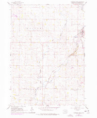
1962 Map of Garretson West
USGS Topo · Published 1977About this map
Garretson and its surrounding rural townships in Minnehaha County are captured here at a moment of transition during the 1960s and 1970s. The town's grid is anchored by the Great Northern railroad line, which runs parallel to the winding course of Split Rock Creek. To the north, the Eros Data Center represents a significant technological installation amidst the agricultural landscape. The map provides a detailed view of the civic and spiritual foundations of the area, featuring landmarks like the Split Rock Ch, White Willow Sch, and Fairview Sch. These local institutions, along with the Summit Hill Cem, trace the community's genealogy across Edison, Brandon, and Red Rock townships. The natural geography is defined by the drainage patterns of West Pipestone Creek and the designated Palisades Recreational Area, highlighting the balance between rural industry and conservation.
Find a feature on this map
22 named features on this map. Tap any name to fly to it.
Don’t see what you’re looking for? This feature index may not catch every label — zoom into the map to look around manually.
Map Details
Editions of this 1962 Garretson West Map
2 editions found
Other maps of this area

1955 · Sioux Falls
USGS Topo · 1:250,000

1958 · Sioux Falls
USGS Topo · 1:250,000

1962 · Dell Rapids
USGS Topo · 1:24,000

1962 · Renner
USGS Topo · 1:24,000

1962 · Brandon
USGS Topo · 1:24,000

1962 · Sioux Falls East
USGS Topo · 1:24,000

1962 · Garretson West
USGS Topo · 1:24,000

1967 · Valley Springs
USGS Topo · 1:24,000

1967 · Garretson East
USGS Topo · 1:24,000

1967 · Jasper
USGS Topo · 1:24,000