
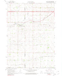
1967 Map of Valley Springs
USGS Topo · Published 1968About this map
Valley Springs serves as the primary hub on this tri-state border map, where the boundaries of South Dakota, Minnesota, and Iowa meet. The landscape is defined by the winding course of Beaver Creek and the steel rails of the Chicago and North Western railroad, which cuts through the northern sections near the small settlement of Manley. This 1960s survey captures the region just as the interstate highway system was being established, showing its intersection with older local infrastructure and several commercial Gravel Pits. Local history is anchored by markers such as Pleasant View Cem and Nerison Cem, while smaller locales like Benclare and Bruce mark the rural expanses. The drainage patterns of Fourmile Creek and Blood Run illustrate the hydrology of the area before modern agricultural shifts fully reshaped the prairie landscape.
Find a feature on this map
22 named features on this map. Tap any name to fly to it.
Don’t see what you’re looking for? This feature index may not catch every label — zoom into the map to look around manually.
Map Details
Editions of this 1967 Valley Springs Map
2 editions found
Other maps of this area

1897 · Canton
USGS Topo · 1:125,000

1900 · Canton
USGS Topo · 1:125,000

1955 · Sioux Falls
USGS Topo · 1:250,000

1958 · Sioux Falls
USGS Topo · 1:250,000

1962 · Klondike
USGS Topo · 1:24,000

1962 · Brandon
USGS Topo · 1:24,000

1962 · Garretson West
USGS Topo · 1:24,000

1967 · Garretson East
USGS Topo · 1:24,000

1967 · Hills
USGS Topo · 1:24,000

1967 · Hills NE
USGS Topo · 1:24,000