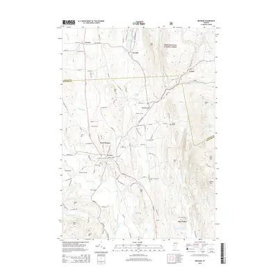
2015 Map of Brandon
USGS Topo · Published 2015About this map
Otter Creek and the Neshobe River converge near the settlement of Brandon, forming a central valley flanked by the rising peaks of the Green Mountain National Forest. This 2015 update reflects the enduring landscape of northern Rutland County, where the village of Forest Dale sits at the foot of Lead Mine Mtn and Birch Hill. The map provides significant detail for genealogists, documenting numerous small burial grounds such as the Gilbert-Cook-Goodrow Cem and the June Cem. Historical transportation patterns are preserved in the naming of local landmarks like Sanderson Bridge and Dean Bridge, while the upland eastern reaches toward Goshen and Sugar Hollow show the topographical transition into the steeper terrain of Chaffee Mtn and Oak Hill. The presence of Fern Lake and Lake Dunmore to the north further defines this region as one shaped by its diverse water bodies and glacial mountain geography.
Find a feature on this map
116 named features on this map. Tap any name to fly to it.
Don’t see what you’re looking for? This feature index may not catch every label — zoom into the map to look around manually.
Map Details
Editions of this 2015 Brandon Map
This is the sole edition of this map. No revisions or reprints were ever made.
Other maps of this area

1891 · Rutland
USGS Topo · 1:62,500

1893 · Rutland
USGS Topo · 1:62,500

1895 · Castleton
USGS Topo · 1:62,500

1897 · Castleton
USGS Topo · 1:62,500

1902 · Brandon
USGS Topo · 1:62,500

1904 · Brandon
USGS Topo · 1:62,500

1915 · Rochester
USGS Topo · 1:62,500

1917 · Rochester
USGS Topo · 1:62,500

1920 · Brandon
USGS Topo · 1:62,500
1943 · Cornwall
USGS Topo · 1:31,680