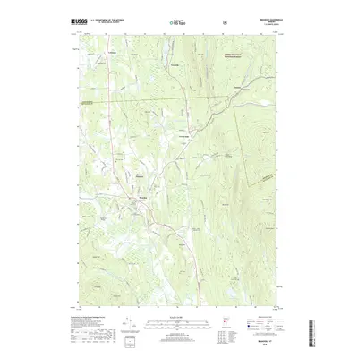
2018 Map of Brandon
USGS Topo · Published 2018About this map
Brandon serves as the central hub of this Vermont landscape, where the Neshobe River winds through the valley floor. The map illustrates a dense network of local history, including numerous family and community burial grounds such as Saint Marys Cem, Maple Street Cem, and the Brandon Town Cem. To the east, the terrain rises sharply into the Green Mountains, dominated by peaks like Lead Mine Mtn and Chaffee Mtn within the Green Mountain National Forest. The transition from the agricultural wetlands of Otter Creek to the high eastern ridges is marked by smaller settlements like Forest Dale and Goshen. This survey captures the relationship between the valley's infrastructure, including landmarks like Sanderson Bridge and Dean Bridge, and the enduring topography of the ridge-and-valley systems typical of the region.
Find a feature on this map
122 named features on this map. Tap any name to fly to it.
Don’t see what you’re looking for? This feature index may not catch every label — zoom into the map to look around manually.
Map Details
Editions of this 2018 Brandon Map
This is the sole edition of this map. No revisions or reprints were ever made.
Other maps of this area

1891 · Rutland
USGS Topo · 1:62,500

1893 · Rutland
USGS Topo · 1:62,500

1895 · Castleton
USGS Topo · 1:62,500

1897 · Castleton
USGS Topo · 1:62,500

1902 · Brandon
USGS Topo · 1:62,500

1904 · Brandon
USGS Topo · 1:62,500

1915 · Rochester
USGS Topo · 1:62,500

1917 · Rochester
USGS Topo · 1:62,500

1920 · Brandon
USGS Topo · 1:62,500
1943 · Cornwall
USGS Topo · 1:31,680