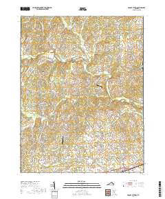
2019 Map of Brandy Station
USGS Topo · Published 2019About this map
Brandy Station and the rising ground of Fleetwood Hill anchor the southeastern corner of this landscape, a region defined by its intersection of river systems and traditional Virginia crossroads. The Hazel River and Rappahannock River flow through the northern reaches, while numerous smaller drainages like Ruffans Run and Indian Run carve the surrounding farmland. This area of Culpeper County remains characterized by scattered hamlets such as Rixeyville, Alanthus, and Lakota, connected by a dense network of country roads like Sheads Mountain Rd and Myers Mill Rd. The transition from the elevations of Sheads Mtn down into the Culpeper Basin is clearly visible in the terrain. Modern infrastructure is represented by the Berryvale Airport and Swan Dam, showing the continued evolution of land use in this historic corridor between the Blue Ridge and the Piedmont.
Find a feature on this map
131 named features on this map. Tap any name to fly to it.
Don’t see what you’re looking for? This feature index may not catch every label — zoom into the map to look around manually.
Map Details
Editions of this 2019 Brandy Station Map
This is the sole edition of this map. No revisions or reprints were ever made.
Other maps of this area

1887 · Spottsylvania
USGS Topo · 1:125,000

1892 · Spottsylvania
USGS Topo · 1:125,000

1892 · Gordonsville
USGS Topo · 1:125,000

1893 · Luray
USGS Topo · 1:125,000

1894 · Warrenton
USGS Topo · 1:125,000

1894 · Warrenton
USGS Topo · 1:62,500

1905 · Luray
USGS Topo · 1:125,000

1927 · Remington
USGS Topo · 1:48,000

1930 · Warrenton
USGS Topo · 1:62,500

1943 · Germanna Bridge
USGS Topo · 1:24,000