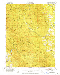
1951 Map of Branscomb
USGS Topo · Published 1953About this map
Branscomb serves as the central settlement in this 1950s survey of the northern California Coast Range, positioned along the upper reaches of the South Fork Eel River. The landscape is defined by a series of prominent northwest-trending elevations, including Lincoln Ridge and Buchana Ridge, which separate the various forks of the Eel River and the Tenmile River. The map highlights a remote terrain dominated by timber and watershed management, evidenced by the numerous gaging stations and fire lookouts atop Cahto Pk and Signal Peak.
Find a feature on this map
101 named features on this map. Tap any name to fly to it.
Don’t see what you’re looking for? This feature index may not catch every label — zoom into the map to look around manually.
Map Details
Editions of this 1951 Branscomb Map
4 editions found

Other maps of this area

1920 · Glenblair
USGS Topo · 1:62,500

1920 · Cummings
USGS Topo · 1:62,500

1920 · Covelo
USGS Topo · 1:62,500

1920 · Fort Bragg
USGS Topo · 1:62,500

1921 · Westport
USGS Topo · 1:62,500

1921 · Branscomb
USGS Topo · 1:62,500

1922 · Willits
USGS Topo · 1:62,500

1942 · Willits
USGS Topo · 1:62,500

1943 · Glenblair
USGS Topo · 1:62,500

1943 · Fort Bragg
USGS Topo · 1:62,500