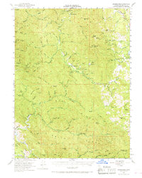
1951 Map of Branscomb
USGS Topo · Published 1968About this map
Branscomb serves as a central hub in this mid-century survey of the Mendocino highlands, where the South Fork Eel River carves through a dense network of ridges. The settlement pattern reflects the area's transition from early pioneer outposts like Wilderness Lodge to modern recreation and infrastructure, as evidenced by the Admiral Standley State Park and a local Landing Strip. The landscape is defined by a series of named elevations including Cahto Pk and Signal Peak, which overlook complex drainage systems such as Tenmile Creek and Jack of Hearts Creek. Insights into local agriculture and land use are visible through features like O'Conner Orchard, while the presence of a Gaging Sta and a Jeep Trail indicates the ongoing management and accessibility of this heavily timbered terrain during the early 1950s.
Find a feature on this map
83 named features on this map. Tap any name to fly to it.
Don’t see what you’re looking for? This feature index may not catch every label — zoom into the map to look around manually.
Map Details
Editions of this 1951 Branscomb Map
4 editions found

Other maps of this area

1920 · Glenblair
USGS Topo · 1:62,500

1920 · Cummings
USGS Topo · 1:62,500

1920 · Covelo
USGS Topo · 1:62,500

1920 · Fort Bragg
USGS Topo · 1:62,500

1921 · Westport
USGS Topo · 1:62,500

1921 · Branscomb
USGS Topo · 1:62,500

1922 · Willits
USGS Topo · 1:62,500

1942 · Willits
USGS Topo · 1:62,500

1943 · Glenblair
USGS Topo · 1:62,500

1943 · Fort Bragg
USGS Topo · 1:62,500