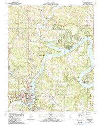
1989 Map of Branson
USGS Topo · Published 1989About this map
Lake Taneycomo snakes through the center of this Ozark landscape, defining the character of Branson and its neighboring settlements. This late-1980s revision documents the area as a growing hub of recreation and local industry, with the White River corridor punctuated by lakeside communities like Rockaway Beach, Edgewater Beach, and Ozark Beach. The map details the civic core of the region, including the Skaggs Community Hospital, several schools, and the Clark Airport south of town.
Find a feature on this map
51 named features on this map. Tap any name to fly to it.
Don’t see what you’re looking for? This feature index may not catch every label — zoom into the map to look around manually.
Map Details
Editions of this 1989 Branson Map
This is the sole edition of this map. No revisions or reprints were ever made.
Other maps of this area

1907 · Forsyth
USGS Topo · 1:125,000

1945 · Harrison
USGS Topo · 1:250,000

1949 · Harrison
USGS Topo · 1:250,000

1950 · Garber
USGS Topo · 1:24,000

1954 · Harrison
USGS Topo · 1:250,000

1955 · Garrison
USGS Topo · 1:24,000

1955 · Day
USGS Topo · 1:24,000

1956 · Table Rock Dam
USGS Topo · 1:24,000

1956 · Garber
USGS Topo · 1:24,000
1956 · Mincy
USGS Topo · 1:24,000