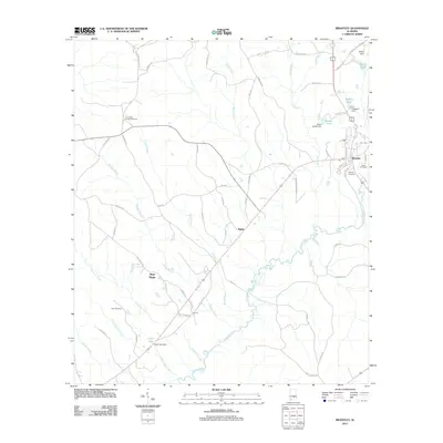
2011 Map of Brantley
USGS Topo · Published 2011About this map
Conecuh River meanders through the heart of this Crenshaw County landscape, defining the topography of a region steeped in Alabama's agricultural and rural traditions. The town of Brantley serves as the primary hub, situated near the confluence of several vital water bodies including Smiths Lake and Thagard Pond. Local history and genealogy are anchored by several established burial sites, including Camerons Chapel Cemetery and Davis Cemetery, which sit alongside a network of family-named roads such as Kimbro Rd and Lester Bell Rd. The map reveals a transition from these clustered settlements to the outlying communities of Theba, New Hope, and Sports. This 2011 survey captures the area's reliance on its waterway system, evidenced by numerous man-made structures like the Bryce Smith Dam and L D Thaggard Dam, which have managed the local hydraulic resources for generations.
Find a feature on this map
69 named features on this map. Tap any name to fly to it.
Don’t see what you’re looking for? This feature index may not catch every label — zoom into the map to look around manually.
Map Details
Editions of this 2011 Brantley Map
This is the sole edition of this map. No revisions or reprints were ever made.
Other maps of this area

1953 · Andalusia
USGS Topo · 1:250,000

1957 · Andalusia
USGS Topo · 1:250,000

1968 · Danleys Crossroads
USGS Topo · 1:24,000

1968 · Glenwood
USGS Topo · 1:24,000

1968 · Bullock
USGS Topo · 1:24,000

1971 · Dozier
USGS Topo · 1:24,000

1971 · Luverne
USGS Topo · 1:24,000

1971 · Brantley
USGS Topo · 1:24,000

1971 · Gantt
USGS Topo · 1:24,000

1971 · Leon
USGS Topo · 1:24,000