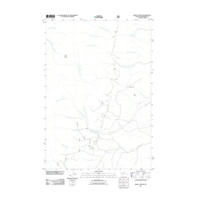
2011 Map of Brays Canyon
USGS Topo · Published 2011About this map
Big Hole Divide forms a primary topographical spine across this southwestern Montana landscape, which is defined by an intricate network of drainages and evidence of mineral exploration. The presence of the Gold Brick Mine on the eastern slopes of Brays Canyon suggests a legacy of prospecting in these highlands. The terrain is deeply carved by water, with Buffalo Creek and its many tributaries—including the Straight Fork Buffalo Creek and Middle Fork Buffalo Creek—dominating the central and southern portions of the sheet. Transportation is limited to rugged routes such as Buffalo Creek Rd, which tracks alongside the water through the steep topography. Further north, the land is drained by the North Fork Hayes Creek and the headwaters of Swamp Creek, illustrating a classic high-country watershed system.
Find a feature on this map
20 named features on this map. Tap any name to fly to it.
Don’t see what you’re looking for? This feature index may not catch every label — zoom into the map to look around manually.
Map Details
Editions of this 2011 Brays Canyon Map
This is the sole edition of this map. No revisions or reprints were ever made.
Other maps of this area

1955 · Dillon
USGS Topo · 1:250,000

1957 · Dillon
USGS Topo · 1:250,000

1958 · Dillon
USGS Topo · 1:250,000

1959 · Polaris
USGS Topo · 1:62,500

1959 · Grant
USGS Topo · 1:62,500

1962 · Dillon
USGS Topo · 1:250,000

1965 · Dillon
USGS Topo · 1:250,000

1978 · Butch Hill
USGS Topo · 1:24,000
1978 · Coyote Creek
USGS Topo · 1:24,000
1981 · Salmon
USGS Topo · 1:100,000