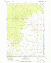
1978 Map of Coyote Creek
USGS Topo · Published 1979About this map
Beaverhead National Forest land defines the western landscape of this high-elevation mountain quadrangle, where resource extraction and water management are the primary human signatures. The map highlights the industrial history of the region with labeled mines and the specific Monument Mine located along Sullivan Gulch. A network of pack and jeep trails provides access to the remote terrain, connecting water sources like Houlihan Springs to the wider drainage system. The complex hydrology is further marked by the Bloody Dick Ditch, an artificial watercourse running parallel to Bloody Dick Creek, which illustrates the era's reliance on irrigation and water diversion for downstream valley use. In the south-central portion of the map, the Horse Prairie Guard Station stands as a focal point for forest management and local administration amidst the numerous named gulches and creek drainages.
Find a feature on this map
21 named features on this map. Tap any name to fly to it.
Don’t see what you’re looking for? This feature index may not catch every label — zoom into the map to look around manually.
Map Details
Editions of this 1978 Coyote Creek Map
This is the sole edition of this map. No revisions or reprints were ever made.
Other maps of this area

1955 · Dubois
USGS Topo · 1:250,000

1955 · Dillon
USGS Topo · 1:250,000

1957 · Dillon
USGS Topo · 1:250,000

1958 · Dubois
USGS Topo · 1:250,000

1958 · Dillon
USGS Topo · 1:250,000

1959 · Grant
USGS Topo · 1:62,500

1962 · Dillon
USGS Topo · 1:250,000

1965 · Dillon
USGS Topo · 1:250,000

1965 · Jeff Davis Peak
USGS Topo · 1:24,000

1965 · Lemhi Pass
USGS Topo · 1:24,000