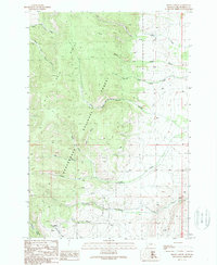
1988 Map of Brays Canyon
USGS Topo · Published 1989About this map
Big Hole Divide forms a prominent natural spine through this high-country landscape within the Beaverhead National Forest. This 1980s provisional study, based on fieldwork from the late 1950s and mid-1980s, captures a complex drainage system where the headwaters of North Fork Fox Creek and South Fork Fox Creek flow northwest while Buffalo Creek and Watson Creek descend toward the southeast. This hydrological split defines the character of the terrain, which is dominated by steep canyon walls and narrow stream valleys.
Find a feature on this map
23 named features on this map. Tap any name to fly to it.
Don’t see what you’re looking for? This feature index may not catch every label — zoom into the map to look around manually.
Map Details
Editions of this 1988 Brays Canyon Map
This is the sole edition of this map. No revisions or reprints were ever made.
Other maps of this area

1955 · Dillon
USGS Topo · 1:250,000

1957 · Dillon
USGS Topo · 1:250,000

1958 · Dillon
USGS Topo · 1:250,000

1959 · Polaris
USGS Topo · 1:62,500

1959 · Grant
USGS Topo · 1:62,500

1962 · Dillon
USGS Topo · 1:250,000

1965 · Dillon
USGS Topo · 1:250,000

1978 · Butch Hill
USGS Topo · 1:24,000
1978 · Coyote Creek
USGS Topo · 1:24,000
1981 · Salmon
USGS Topo · 1:100,000