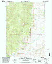
1997 Map of Brays Canyon
USGS Topo · Published 2002About this map
The Big Hole Divide forms a significant topographic backbone in this section of the Beaverhead National Forest, dictating the flow of numerous mountain drainages. Mapping revised by the USDA Forest Service in the late 1990s captures a landscape defined by its complex network of forks and canyons, including the prominent Brays Canyon and Browns Canyon. To the west, waters feed toward the Big Hole River system via channels like the North Fork and South Fork, while eastern slopes drain toward the Dillon Ranger District through Hayes Creek. Small-scale resource extraction is noted by a Gravel Pit and isolated Prospect sites, while a high-altitude Reservoir and a system of 4wd routes suggest the area's utility for water management and backcountry access. This survey provides a clear view of the drainage patterns and rugged relief that characterize this high Montana interior before the turn of the millennium.
Find a feature on this map
23 named features on this map. Tap any name to fly to it.
Don’t see what you’re looking for? This feature index may not catch every label — zoom into the map to look around manually.
Map Details
Editions of this 1997 Brays Canyon Map
This is the sole edition of this map. No revisions or reprints were ever made.
Other maps of this area

1955 · Dillon
USGS Topo · 1:250,000

1957 · Dillon
USGS Topo · 1:250,000

1958 · Dillon
USGS Topo · 1:250,000

1959 · Polaris
USGS Topo · 1:62,500

1959 · Grant
USGS Topo · 1:62,500

1962 · Dillon
USGS Topo · 1:250,000

1965 · Dillon
USGS Topo · 1:250,000

1978 · Butch Hill
USGS Topo · 1:24,000
1978 · Coyote Creek
USGS Topo · 1:24,000
1981 · Salmon
USGS Topo · 1:100,000