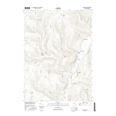
2016 Map of Breakabeen
USGS Topo · Published 2016About this map
Schoharie Creek defines the valley floor of this Schoharie County region, providing a corridor for settlement and transit below the surrounding uplands. The village of Breakabeen sits along the eastern bank of the creek, while the settlement of West Fulton is tucked into the hills at the junction of several local routes. The terrain is marked by distinctive formations such as Walhalla Rocks and Towpath Mtn, with many smaller hollows like Dibble Hollow and Warner Hollow branching off the main waterways. For genealogists, the map is remarkably dense with burial grounds, including the Breakabeen Cem and the Patria Cem. Recreational features like Max Shaul State Park Rd and the Panther Path indicate the area's contemporary role as a destination for outdoor activity amidst its traditional farming and forestry landscape.
Find a feature on this map
70 named features on this map. Tap any name to fly to it.
Don’t see what you’re looking for? This feature index may not catch every label — zoom into the map to look around manually.
Map Details
Editions of this 2016 Breakabeen Map
This is the sole edition of this map. No revisions or reprints were ever made.
Other maps of this area

1898 · Schoharie
USGS Topo · 1:62,500

1900 · Schoharie
USGS Topo · 1:62,500

1900 · Schoharie
USGS Topo · 1:31,680

1901 · Gilboa
USGS Topo · 1:62,500

1903 · Gilboa
USGS Topo · 1:62,500

1904 · Richmondville
USGS Topo · 1:62,500

1904 · Hobart
USGS Topo · 1:62,500

1943 · Cobleskill
USGS Topo · 1:24,000

1943 · Breakabeen
USGS Topo · 1:24,000
1943 · Schoharie
USGS Topo · 1:24,000