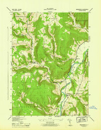
1946 Map of Breakabeen
USGS Topo · Published 1946About this map
Schoharie Creek dominates the eastern valley of this terrain, where the settlement of Breakabeen sits at the junction of the river road and the Keyser Kill. The landscape is defined by its deep hollows and high ridges, including Burnt Hill and Towpath Mtn. Local life in the mid-1940s remained centered around small rural nodes like Vintonton, Patria, and Housons Corners, each supported by numbered district schools such as School No 9 and School No 11.
Find a feature on this map
36 named features on this map. Tap any name to fly to it.
Don’t see what you’re looking for? This feature index may not catch every label — zoom into the map to look around manually.
Map Details
Editions of this 1946 Breakabeen Map
This is the sole edition of this map. No revisions or reprints were ever made.
Other maps of this area

1898 · Schoharie
USGS Topo · 1:62,500

1900 · Schoharie
USGS Topo · 1:62,500

1900 · Schoharie
USGS Topo · 1:31,680

1901 · Gilboa
USGS Topo · 1:62,500

1903 · Gilboa
USGS Topo · 1:62,500

1904 · Richmondville
USGS Topo · 1:62,500

1904 · Hobart
USGS Topo · 1:62,500

1943 · Cobleskill
USGS Topo · 1:24,000

1943 · Breakabeen
USGS Topo · 1:24,000
1943 · Schoharie
USGS Topo · 1:24,000