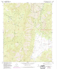
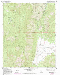
1972 Map of Breckenridge Mountain
USGS Topo · Published 1994About this map
Breckenridge Mountain rises as the central landmark of this high-elevation landscape within the Sequoia National Forest. The 1970s terrain is characterized by a network of seasonal springs, including Bear Trap Spring and Agua Fria Spring, which feed complex drainage systems like Caliente Creek and Canyon Creek. Human activity is marked by a transition from industrial extractive sites to recreational and agricultural uses. Resource extraction is evidenced by the Tungsten Chief Mine and the Dutchman Prospect, while the southeast corner reveals the more open landscape of Walker Basin. Here, the presence of the Rankin Ranch, a small Cem, and a Landing Strip suggests a shift toward settled ranching and private landholdings. Communication infrastructure is prominent on the peaks, with a Lookout Tower and several radio facilities like the Radio Tower (KBAK) overlooking the various meadows and canyons.
Find a feature on this map
53 named features on this map. Tap any name to fly to it.
Don’t see what you’re looking for? This feature index may not catch every label — zoom into the map to look around manually.
Map Details
Editions of this 1972 Breckenridge Mountain Map
5 editions found
Other maps of this area

1906 · Kernville
USGS Topo · 1:125,000

1908 · Kernville
USGS Topo · 1:125,000

1914 · Caliente
USGS Topo · 1:125,000

1915 · Mojave
USGS Topo · 1:125,000

1920 · Delonagha
USGS Topo · 1:62,500

1926 · Glennville
USGS Topo · 1:62,500

1929 · Bena
USGS Topo · 1:31,680

1932 · Bena
USGS Topo · 1:31,680

1936 · Tobias Peak
USGS Topo · 1:125,000

1943 · Emerald Mtn
USGS Topo · 1:62,500