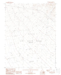
1988 Map of Breen Creek
USGS Topo · Published 1988About this map
Nellis Air Force Range (Restricted Area) dominates this high-desert landscape in the late 1980s, reflecting the military's expansive presence in southern Nevada. The terrain is defined by the ephemeral drainage of Breen Creek as it winds toward the broad expanse of Cactus Flat. Human activity in this restricted zone is marked by functional landmarks such as a series of Tower 54 Ft structures and various unnamed Site locations.
Find a feature on this map
11 named features on this map. Tap any name to fly to it.
Don’t see what you’re looking for? This feature index may not catch every label — zoom into the map to look around manually.
Map Details
Editions of this 1988 Breen Creek Map
This is the sole edition of this map. No revisions or reprints were ever made.
Other maps of this area

1908 · Kawich
USGS Topo · 1:250,000

1942 · Cactus Range
USGS Topo · 1:125,000

1942 · Reveille Peak
USGS Topo · 1:125,000

1952 · Stinking Spring
USGS Topo · 1:62,500

1952 · Mellan
USGS Topo · 1:62,500

1952 · Kawich Peak
USGS Topo · 1:62,500

1952 · Quartzite Mtn
USGS Topo · 1:62,500

1954 · Goldfield
USGS Topo · 1:250,000

1955 · Goldfield
USGS Topo · 1:250,000

1958 · Goldfield
USGS Topo · 1:250,000