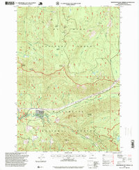
1997 Map of Breitenbush Hot Springs
USGS Topo · Published 1999About this map
Breitenbush Hot Springs serves as a focal point in this high-elevation landscape, where the confluence of geothermal activity and forest management is clearly mapped. The area around the Breitenbush Guard Station and the Powerhouse reflects the localized infrastructure developed to support backcountry access and utility within the Willamette National Forest. This 1990s revision captures a transition in forest use, documenting several resource extraction sites like the Queen Quarry and Little Cedar Quarry alongside recreational landmarks and protected wilderness boundaries.
Find a feature on this map
65 named features on this map. Tap any name to fly to it.
Don’t see what you’re looking for? This feature index may not catch every label — zoom into the map to look around manually.
Map Details
Editions of this 1997 Breitenbush Hot Springs Map
This is the sole edition of this map. No revisions or reprints were ever made.
Other maps of this area

1927 · Mt. Jefferson
USGS Topo · 1:125,000

1929 · Mill City
USGS Topo · 1:125,000

1930 · Mt. Jefferson
USGS Topo · 1:125,000

1953 · Salem
USGS Topo · 1:250,000

1954 · Salem
USGS Topo · 1:250,000

1955 · Bend
USGS Topo · 1:250,000

1956 · Battle Ax
USGS Topo · 1:62,500

1956 · Detroit
USGS Topo · 1:62,500

1957 · Bend
USGS Topo · 1:250,000

1958 · Bend
USGS Topo · 1:250,000