
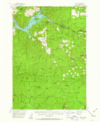
1956 Map of Detroit
USGS Topo · Published 1958About this map
The Detroit Reservoir dominates the northern landscape of this mid-1950s survey, where the recently completed Detroit Dam has fundamentally altered the path of the North Santiam River. This era of transformation is captured as the town of Detroit and its neighbor Idanha adjust to the new shoreline and the development of Detroit Lake State Park. Beyond the rising waters, the map reveals a rugged timber and wilderness interior within the Willamette National Forest, marked by numerous lookout stations and a network of fire-access trails.
Find a feature on this map
91 named features on this map. Tap any name to fly to it.
Don’t see what you’re looking for? This feature index may not catch every label — zoom into the map to look around manually.
Map Details
Editions of this 1956 Detroit Map
2 editions found
Other maps of this area

1927 · Mt. Jefferson
USGS Topo · 1:125,000

1929 · Mill City
USGS Topo · 1:125,000

1929 · Three Sisters
USGS Topo · 1:125,000

1930 · Mt. Jefferson
USGS Topo · 1:125,000

1932 · Three Sisters
USGS Topo · 1:125,000

1934 · Mc Kenzie Bridge
USGS Topo · 1:96,000

1940 · Mc Kenzie Bridge
USGS Topo · 1:125,000

1953 · Salem
USGS Topo · 1:250,000

1954 · Salem
USGS Topo · 1:250,000

1955 · Cascadia
USGS Topo · 1:62,500