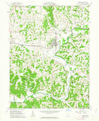
1961 Map of Bremen
USGS Topo · Published 1963About this map
Bremen serves as the central hub for this early 1960s survey, situated at the junction of the Pennsylvania and New York Central railroads. The surrounding landscape of Fairfield and Perry Counties is defined by the winding paths of Rush Creek and Little Rush Creek, which frame a region heavily marked by the energy industry. Numerous Oil Wells and Gas Wells are scattered across the hillsides, reflecting a local economy tied to natural resource extraction alongside traditional farming.
Find a feature on this map
54 named features on this map. Tap any name to fly to it.
Don’t see what you’re looking for? This feature index may not catch every label — zoom into the map to look around manually.
Map Details
Editions of this 1961 Bremen Map
Other maps of this area

1907 · Logan
USGS Topo · 1:62,500

1907 · Lancaster
USGS Topo · 1:62,500

1907 · Thurston
USGS Topo · 1:62,500

1909 · Thornville
USGS Topo · 1:62,500

1909 · Lancaster
USGS Topo · 1:62,500

1909 · Logan
USGS Topo · 1:62,500

1909 · Thurston
USGS Topo · 1:62,500

1947 · Columbus
USGS Topo · 1:250,000

1961 · Columbus
USGS Topo · 1:250,000

1961 · Rushville
USGS Topo · 1:24,000