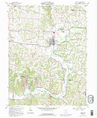
1992 Map of Bremen
USGS Topo · Published 1995About this map
Bremen serves as the central hub of this topographical study, situated at the confluence of several vital waterways including Rush Creek and Raccoon Creek. The landscape is heavily defined by the Rush Creek Oil Field, where numerous oil and gas wells are interspersed among established agricultural tracts and small settlements like North Berne and Geneva. The presence of industrial remnants, such as a Strip Mine and a Gravel Pit, indicates a territory where natural resource extraction has long shaped local development alongside traditional farming.
Find a feature on this map
50 named features on this map. Tap any name to fly to it.
Don’t see what you’re looking for? This feature index may not catch every label — zoom into the map to look around manually.
Map Details
Editions of this 1992 Bremen Map
This is the sole edition of this map. No revisions or reprints were ever made.
Other maps of this area

1907 · Logan
USGS Topo · 1:62,500

1907 · Lancaster
USGS Topo · 1:62,500

1907 · Thurston
USGS Topo · 1:62,500

1909 · Thornville
USGS Topo · 1:62,500

1909 · Lancaster
USGS Topo · 1:62,500

1909 · Logan
USGS Topo · 1:62,500

1909 · Thurston
USGS Topo · 1:62,500

1947 · Columbus
USGS Topo · 1:250,000

1961 · Columbus
USGS Topo · 1:250,000

1961 · Rushville
USGS Topo · 1:24,000