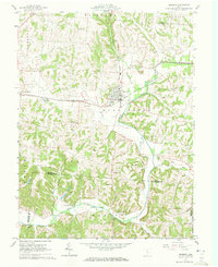
1961 Map of Bremen
USGS Topo · Published 1972About this map
The Rush Creek Oil Field dominates the central landscape of this 1961 Fairfield County survey, where dozens of individual oil wells are clustered along the valley floors and ridges. At the heart of this industrial activity is Bremen, a hub where the Pennsylvania and New York Central railroads intersect, facilitating the movement of resources through the region. This transportation network also serves the smaller settlements of North Berne and Geneva, connecting the rural interior of Richland and Rush Creek townships.
Find a feature on this map
47 named features on this map. Tap any name to fly to it.
Don’t see what you’re looking for? This feature index may not catch every label — zoom into the map to look around manually.
Map Details
Editions of this 1961 Bremen Map
Other maps of this area

1907 · Logan
USGS Topo · 1:62,500

1907 · Lancaster
USGS Topo · 1:62,500

1907 · Thurston
USGS Topo · 1:62,500

1909 · Thornville
USGS Topo · 1:62,500

1909 · Lancaster
USGS Topo · 1:62,500

1909 · Logan
USGS Topo · 1:62,500

1909 · Thurston
USGS Topo · 1:62,500

1947 · Columbus
USGS Topo · 1:250,000

1961 · Columbus
USGS Topo · 1:250,000

1961 · Rushville
USGS Topo · 1:24,000