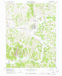
1961 Map of Bremen
USGS Topo · Published 1977About this map
The village of Bremen sits at the junction of Rush Creek and Little Rush Creek, serving as a central hub for the surrounding rural townships in Fairfield and Perry Counties. This mid-century landscape is defined by its industrial activity, notably the extensive Oil Field and numerous individual oil wells dotting the valleys between Raccoon Run and Turkey Run. The rail infrastructure of Conrail cuts through the terrain, connecting the larger settlement at Bremen with smaller locales like North Berne and Geneva.
Find a feature on this map
50 named features on this map. Tap any name to fly to it.
Don’t see what you’re looking for? This feature index may not catch every label — zoom into the map to look around manually.
Map Details
Editions of this 1961 Bremen Map
Other maps of this area

1907 · Logan
USGS Topo · 1:62,500

1907 · Lancaster
USGS Topo · 1:62,500

1907 · Thurston
USGS Topo · 1:62,500

1909 · Thornville
USGS Topo · 1:62,500

1909 · Lancaster
USGS Topo · 1:62,500

1909 · Logan
USGS Topo · 1:62,500

1909 · Thurston
USGS Topo · 1:62,500

1947 · Columbus
USGS Topo · 1:250,000

1961 · Columbus
USGS Topo · 1:250,000

1961 · Rushville
USGS Topo · 1:24,000