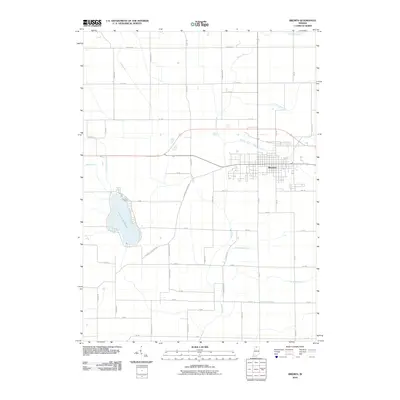
2010 Map of Bremen
USGS Topo · Published 2010About this map
Bremen serves as the central hub of this Marshall County landscape, where the town's street grid is neatly framed by the Middle Fork Yellow River and the main Yellow River. The surrounding rural territory is defined by an extensive and meticulously named drainage system, reflecting the intensive agricultural development of the region. Family names are preserved through features like the Sarah Hershberger Ditch, William Forsythe Ditch, and George Bowser Ditch, offering specific geographical anchors for genealogists and local historians. To the west, the substantial Lake of the Wood dominates the terrain, while the historical transit corridor of the Plymouth Goshen Trl and Miami Trl cut across the standard sectional road grid, marking older routes through the Indiana countryside.
Find a feature on this map
43 named features on this map. Tap any name to fly to it.
Don’t see what you’re looking for? This feature index may not catch every label — zoom into the map to look around manually.
Map Details
Editions of this 2010 Bremen Map
This is the sole edition of this map. No revisions or reprints were ever made.
Other maps of this area

1953 · Chicago
USGS Topo · 1:250,000

1957 · Chicago
USGS Topo · 1:250,000

1957 · Inwood
USGS Topo · 1:24,000

1957 · Plymouth
USGS Topo · 1:24,000

1958 · Bremen
USGS Topo · 1:24,000

1958 · La Paz
USGS Topo · 1:24,000

1958 · Nappanee West
USGS Topo · 1:24,000

1958 · Bourbon
USGS Topo · 1:24,000

1958 · Lakeville
USGS Topo · 1:24,000
1961 · Wakarusa
USGS Topo · 1:24,000