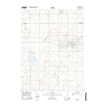
2016 Map of Bremen
USGS Topo · Published 2016About this map
Bremen serves as the primary hub of this northern Indiana landscape, where the town's street grid meets the winding course of the Middle Fork Yellow River. This 2016 survey illustrates a region defined by sophisticated agricultural water management, evidenced by an extensive network of named waterways such as the Sarah Hershberger Ditch, William Forsythe Ditch, and August Mentzel Ditch. These features, often bearing local family names, highlight the historical effort to drain the fertile till plains for cultivation.
Find a feature on this map
57 named features on this map. Tap any name to fly to it.
Don’t see what you’re looking for? This feature index may not catch every label — zoom into the map to look around manually.
Map Details
Editions of this 2016 Bremen Map
This is the sole edition of this map. No revisions or reprints were ever made.
Other maps of this area

1953 · Chicago
USGS Topo · 1:250,000

1957 · Chicago
USGS Topo · 1:250,000

1957 · Inwood
USGS Topo · 1:24,000

1957 · Plymouth
USGS Topo · 1:24,000

1958 · Bremen
USGS Topo · 1:24,000

1958 · La Paz
USGS Topo · 1:24,000

1958 · Nappanee West
USGS Topo · 1:24,000

1958 · Bourbon
USGS Topo · 1:24,000

1958 · Lakeville
USGS Topo · 1:24,000
1961 · Wakarusa
USGS Topo · 1:24,000