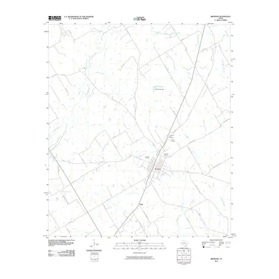
2010 Map of Bremond
USGS Topo · Published 2010About this map
Bremond is the central hub of this Robertson County landscape, characterized by a grid-iron street pattern and a concentration of local history markers. To the north of the town center, a cluster of burial grounds including Cloverleaf Rest Cemetery, Harper Cemetery, and Saint Mary Cemetery provides significant points of interest for genealogists tracing family roots in this part of Texas. The surrounding countryside is defined by an intricate network of waterways, with the Little Brazos River snaking through the northwest and numerous named drainages like Alligator Creek, Copperas Creek, and Big Willow Creek carving through the agricultural terrain.
Find a feature on this map
54 named features on this map. Tap any name to fly to it.
Don’t see what you’re looking for? This feature index may not catch every label — zoom into the map to look around manually.
Map Details
Editions of this 2010 Bremond Map
This is the sole edition of this map. No revisions or reprints were ever made.
Other maps of this area

1954 · Waco
USGS Topo · 1:250,000

1955 · Waco
USGS Topo · 1:250,000

1957 · McClanahan
USGS Topo · 1:24,000

1961 · Baileyville
USGS Topo · 1:24,000

1962 · Hammond
USGS Topo · 1:24,000

1962 · Reagan
USGS Topo · 1:24,000

1962 · Bremond
USGS Topo · 1:24,000

1962 · Petteway
USGS Topo · 1:24,000
1962 · Owensville
USGS Topo · 1:24,000

1965 · Kosse West
USGS Topo · 1:24,000