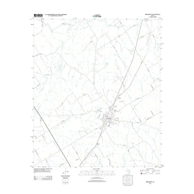
2013 Map of Bremond
USGS Topo · Published 2013About this map
Bremond serves as the focal point of this Robertson County landscape, where the grid of the town site meets a complex network of rural routes and watercourses. The local geography is defined by the Little Brazos River and its numerous tributaries, including Copperas Cr and Alligator Cr. For those tracing local heritage, several burial sites are documented across the area, from the central Bremond Cem and Saint Mary Cem to the more outlying Cloverleaf Rest Cem and Harper Cem. To the south, the small community of Hogg appears along the roadway. The landscape is a mix of agricultural plots and drainage basins like Wachel Lake and Big Willow Cr, illustrating the relationship between the regional watershed and the established road system including FM-46 and Railroad Rd.
Find a feature on this map
79 named features on this map. Tap any name to fly to it.
Don’t see what you’re looking for? This feature index may not catch every label — zoom into the map to look around manually.
Map Details
Editions of this 2013 Bremond Map
This is the sole edition of this map. No revisions or reprints were ever made.
Other maps of this area

1954 · Waco
USGS Topo · 1:250,000

1955 · Waco
USGS Topo · 1:250,000

1957 · McClanahan
USGS Topo · 1:24,000

1961 · Baileyville
USGS Topo · 1:24,000

1962 · Hammond
USGS Topo · 1:24,000

1962 · Reagan
USGS Topo · 1:24,000

1962 · Bremond
USGS Topo · 1:24,000

1962 · Petteway
USGS Topo · 1:24,000
1962 · Owensville
USGS Topo · 1:24,000

1965 · Kosse West
USGS Topo · 1:24,000