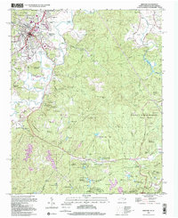
1997 Map of Brevard
USGS Topo · Published 2001About this map
Brevard and its surrounding mountain communities are captured in the late 1990s, revealing a landscape defined by the French Broad River and the expansive reach of the Pisgah National Forest and Dupont State Forest. The map documents a blend of residential growth in areas like Broadview Estates and Forest Hills alongside industrial sites such as a chemical plant and the Brevard Landing Strip. For genealogists and local historians, several family-named landmarks and resting places are noted, including the Glazener Cem, Wilson Cem, and the Rosenwald School. The terrain is marked by distinctive peaks like Sugar Loaf Mountain and Becky Mountain, with numerous falls and lakes such as Glencannon Falls and Marchmans Lake feeding the local waterways near the Tennessee Valley Divide.
Find a feature on this map
93 named features on this map. Tap any name to fly to it.
Don’t see what you’re looking for? This feature index may not catch every label — zoom into the map to look around manually.
Map Details
Editions of this 1997 Brevard Map
This is the sole edition of this map. No revisions or reprints were ever made.
Other maps of this area

1905 · Pisgah
USGS Topo · 1:125,000

1906 · Pisgah
USGS Topo · 1:125,000

1935 · Brevard
USGS Topo · 1:24,000

1935 · Eastatoe Gap
USGS Topo · 1:24,000

1935 · Standingstone Mtn.
USGS Topo · 1:24,000

1935 · Horse Shoe
USGS Topo · 1:24,000

1935 · Rosman
USGS Topo · 1:24,000

1935 · Table Rock
USGS Topo · 1:24,000

1935 · Shining Rock
USGS Topo · 1:24,000

1935 · Pisgah Forest
USGS Topo · 1:24,000