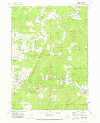
1971 Map of Bridge
USGS Topo · Published 1973About this map
The confluence of the North Fork Coquille River, East Fork Coquille River, and Middle Fork Coquille River defines the landscape of Coos County in the early 1970s. The settlement of Gravel Ford serves as a central hub, where the Gravel Ford Cem and Bennett County Park sit near the winding riverbanks. Further south, the community of Bridge anchors the valley near the mouth of Big Creek, while Echo Valley and the Hoffman Memorial State Wayside indicate a blend of local agriculture and public recreation spaces.
Find a feature on this map
46 named features on this map. Tap any name to fly to it.
Don’t see what you’re looking for? This feature index may not catch every label — zoom into the map to look around manually.
Map Details
Editions of this 1971 Bridge Map
This is the sole edition of this map. No revisions or reprints were ever made.
Other maps of this area

1896 · Coos Bay
USGS Topo · 1:125,000

1898 · Coos Bay
USGS Topo · 1:125,000

1899 · Port Orford
USGS Topo · 1:125,000

1900 · Coos Bay
USGS Topo · 1:125,000

1903 · Port Orford
USGS Topo · 1:125,000

1928 · Sitkum
USGS Topo · 1:125,000

1942 · Coquille
USGS Topo · 1:62,500

1945 · Coquille
USGS Topo · 1:62,500

1954 · Coos Bay
USGS Topo · 1:250,000

1954 · Bone Mountain
USGS Topo · 1:62,500