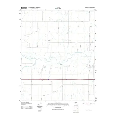
2012 Map of Bridgeport
USGS Topo · Published 2012About this map
The Canadian River meanders through the central plains of Caddo County, carving distinct topographical features such as White Canyon and Fire Canyon. The small community of Bridgeport sits along the eastern edge of the quadrangle, where a regular grid of streets including Market St and Broadway Ave meets the surrounding rural landscape. This area represents a typical Oklahoma ranching and agricultural setting, where the section-line road system facilitates travel between isolated homesteads and water sources. To the south, the Bethel Cem is located near the intersection of Bethel Rd and E1040 Rd, serving as a focal point for local genealogical interest. Several drainages, including Lariat Cr, Deer Cr, and Dead Woman Cr, feed into the river system, defining the drainage patterns of this prairie environment.
Find a feature on this map
42 named features on this map. Tap any name to fly to it.
Don’t see what you’re looking for? This feature index may not catch every label — zoom into the map to look around manually.
Map Details
Editions of this 2012 Bridgeport Map
This is the sole edition of this map. No revisions or reprints were ever made.
Other maps of this area

1942 · Geary
USGS Topo · 1:62,500

1951 · Binger
USGS Topo · 1:62,500

1955 · Clinton
USGS Topo · 1:250,000

1957 · Clinton
USGS Topo · 1:250,000

1961 · Eakly
USGS Topo · 1:62,500

1964 · Weatherford
USGS Topo · 1:62,500

1979 · Hinton
USGS Topo · 1:24,000
1979 · Geary North
USGS Topo · 1:24,000
1979 · Geary South
USGS Topo · 1:24,000

1979 · Greenfield
USGS Topo · 1:24,000