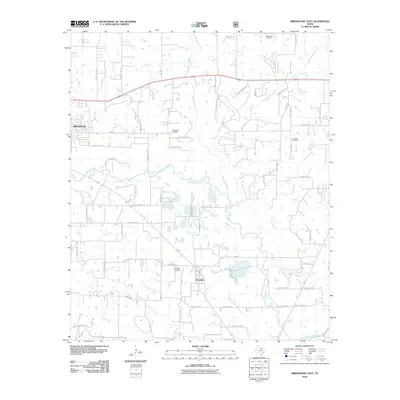
2010 Map of Bridgeport East
USGS Topo · Published 2010About this map
The West Fork Trinity River winds through this Wise County landscape, defining the topography between the city of Bridgeport and the settlement of Paradise. This 2010 survey illustrates the proximity of the Bridgeport Gas Field to residential growth, showing a complex network of local roads such as Cuba Rd and Schoolhouse Rd. Genealogists will find several notable burial sites including Valley View Cemetery in the north and Paradise Cemetery near the town center. The drainage patterns are well-defined by numerous tributaries like Big Sandy Creek and Waggoner Branch, which feed into the river system. The presence of the Prescott Cemetery and established routes like Old Flatwood Rd provide points of reference for those researching family land holdings and historical property boundaries in this part of North Texas.
Find a feature on this map
80 named features on this map. Tap any name to fly to it.
Don’t see what you’re looking for? This feature index may not catch every label — zoom into the map to look around manually.
Map Details
Editions of this 2010 Bridgeport East Map
This is the sole edition of this map. No revisions or reprints were ever made.
Other maps of this area

1924 · Sunset 4-d
USGS Topo · 1:48,000

1930 · Boyd
USGS Topo · 1:62,500

1954 · Sherman
USGS Topo · 1:250,000

1958 · Sherman
USGS Topo · 1:250,000

1960 · Bridgeport West
USGS Topo · 1:24,000

1960 · Bridgeport East
USGS Topo · 1:24,000

1960 · Decatur
USGS Topo · 1:24,000

1960 · Boyd
USGS Topo · 1:24,000

1960 · Cottondale
USGS Topo · 1:24,000
1960 · Boonsville
USGS Topo · 1:24,000