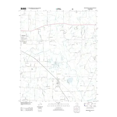
2013 Map of Bridgeport East
USGS Topo · Published 2013About this map
Bridgeport and the surrounding Wise County landscape are defined by the winding course of the W Fork Trinity River and its numerous tributaries. This survey captures a rural landscape where industrial activity at the Bridgeport Gas Field exists alongside aviation hubs like Teate Field Airport and Jackson (Bill) Airport. The town of Paradise serves as a secondary focal point, surrounded by small drainage systems like Rush Cr and Martin Br. Evidence of local heritage and family lineages is preserved through numerous burial grounds, including the Valley View Cem and Prescott Cem. The transition from town to country is marked by a dense network of county roads and distinctive naming conventions such as Comanche Moon Trl, reflecting the area's geography and history at the start of the 21st century.
Find a feature on this map
122 named features on this map. Tap any name to fly to it.
Don’t see what you’re looking for? This feature index may not catch every label — zoom into the map to look around manually.
Map Details
Editions of this 2013 Bridgeport East Map
This is the sole edition of this map. No revisions or reprints were ever made.
Other maps of this area

1924 · Sunset 4-d
USGS Topo · 1:48,000

1930 · Boyd
USGS Topo · 1:62,500

1954 · Sherman
USGS Topo · 1:250,000

1958 · Sherman
USGS Topo · 1:250,000

1960 · Bridgeport West
USGS Topo · 1:24,000

1960 · Bridgeport East
USGS Topo · 1:24,000

1960 · Decatur
USGS Topo · 1:24,000

1960 · Boyd
USGS Topo · 1:24,000

1960 · Cottondale
USGS Topo · 1:24,000
1960 · Boonsville
USGS Topo · 1:24,000