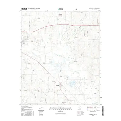
2016 Map of Bridgeport East
USGS Topo · Published 2016About this map
The West Fork Trinity River carves a winding path through the center of this Wise County landscape, creating a broad drainage basin defined by numerous tributaries. North of the river, the protected environment of the Lyndon B. Johnson National Grassland preserves the natural character of the terrain, while the residential streets of eastern Bridgeport occupy the western margin. This area reflects a long-standing agricultural and rural history, evidenced by the scattered distribution of family and community burial grounds such as Valley View Cem, Prescott Cem, and Paradise Cem. To the south, the settlement of Paradise sits at a crossroads of county roads and local transit, with the small landing strip at Teate Field serving as a local landmark. The map reveals how the landscape transition from the grassland to the river valley has influenced the placement of original farm-to-market roads and the development of the river-fed agricultural lands along Big Sandy Cr and Waggoner Br.
Find a feature on this map
102 named features on this map. Tap any name to fly to it.
Don’t see what you’re looking for? This feature index may not catch every label — zoom into the map to look around manually.
Map Details
Editions of this 2016 Bridgeport East Map
This is the sole edition of this map. No revisions or reprints were ever made.
Other maps of this area

1924 · Sunset 4-d
USGS Topo · 1:48,000

1930 · Boyd
USGS Topo · 1:62,500

1954 · Sherman
USGS Topo · 1:250,000

1958 · Sherman
USGS Topo · 1:250,000

1960 · Bridgeport West
USGS Topo · 1:24,000

1960 · Bridgeport East
USGS Topo · 1:24,000

1960 · Decatur
USGS Topo · 1:24,000

1960 · Boyd
USGS Topo · 1:24,000

1960 · Cottondale
USGS Topo · 1:24,000
1960 · Boonsville
USGS Topo · 1:24,000